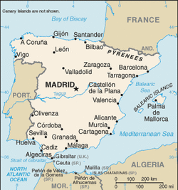
Spain
Total Area: 505,370 sq km
Land Area: 498,980 sq km
Water Area: 6,390 sq km
Size comparison to U.S. territory: slightly more than twice the size of Oregon
Countries that share a border and distance: Andorra 63.7 km, France 623 km, Gibralter 1.2 km, Portugal 1,214 km, Morocco(Ceuta) 6.3 km, Morocco(Melilla) 9.6 km
Total distance of coastline: 4,964 km
Climate: Temperate; clear, hot summers in interior, more moderate and cloudy along the coast; cloudy, cold winters in interior, partly cloudy and cool along the coast
Terrain: flat to dissected plateau surrounded by rugged hills; Pyrenees mountains in north
Point of lowest elevation: Atlantic Ocean (0 m)
Point of highest elevation: Pico de Teide on Canary Islands (3,718)
Terrain: flat to dissected plateau surrounded by rugged hills; Pyrenees mountains in north
Point of lowest elevation: Atlantic Ocean (0 m)
Point of highest elevation: Pico de Teide on Canary Islands (3,718)
